Northern England: Bamburgh, Northumberland
Distance: 23km/6 miles
Time: 6hrs
Type: Coastal
Where: Linear walk from Bamburgh to Craster
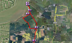
Start: Bamburgh (NU183349).
End: Craster (NU258199).
Terrain: Easy, fairly level coastal path along sandy beaches, dunes and low cliffs. Some stretches of road
Maps: OS Explorer 340 & 332; Landranger 75 & 81
Northumberland’s coastline – a designated Area of Outstanding Natural Beauty – is duly renowned for its magnificent long sandy beaches and impressive castles. The Northumberland Coast Path (part of the North Sea Trail) runs for 103km/64 miles from Cresswell in the south to Berwick-upon-Tweed in the north. The route is well signposted and fairly level, and can be comfortably covered in five or six days. This walk samples one of its finest stretches, taking in Bamburgh and Dunstanburgh Castles – two of Northumberland’s most iconic sights. Since this is a linear walk – there are bus connections between each end – it might be best to take the bus out and walk back (the route can be walked in either direction). Keep an eye on the tides – some of the beaches are better walked when the tide is low but alternative paths go through the dunes.
![]() Click here to download a route card
Click here to download a route card
Click here to download the GPS data for this route as an Anquet file
Click here to download the GPS data for this route as a GPX file
Click below to see a route profile and view the route on an Ordnance Survey map

Click to enlarge
Click here to upload photos taken along this route
- This entry was posted on: Tuesday, May 26th, 2009 at 1:20 pm
- Filed under: Walks, Walks Archive
- Tags: Bamburgh, Northern England, northumberland, routemaster, routes
- Follow responses with this feed: RSS 2.0
- You can leave a response, or trackback from your own site.

