
Southern England: The Eastons and Tilty
DISTANCE: 11km/7miles
TIME: 5.5 hrs
TYPE: Countryside and Villages
NAVIGATION: Level 1
FITNESS: Level 1
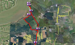
WHERE: Circular walk from Duron Hill via Great Easton, Little Easton and Tilty.
START/END: Three Horseshoes PH (TL604268)
TERRAIN: Undulating Countryside, grassy tracks and lanes.
MAPS: OS Explorer 195.
This delightful circular walk highlights one of Essex’s secret corners. You will pass the 12th-century remains of Tilty Abbey, once a thriving community with its own vineyard, and follow a path used for centuries to Tilty church. Other highlights include 12th-century Little Easton church and its unusual Louvain Crusader tomb and the Norman motte on private land to the right of the church. Here too is Easton Lodge, once home to Edward VII’s mistress, and its gardens, which are open from Easter until October.
![]() Click here to download pdf routecard
Click here to download pdf routecard
Click here to download the GPS data for this route as an Anquet file
Click here to download the GPS data for this route as a GPX file
Click below to see a route profile and view the route on an Ordnance Survey map

Click to enlarge
- This entry was posted on: Wednesday, February 25th, 2009 at 7:19 pm
- Filed under: Current Walk, Latest Walks, Walks
- Tags: Essex, Southern England
- Follow responses with this feed: RSS 2.0
- You can leave a response, or trackback from your own site.